7 Days Rongai Route Overview
This 7 day Rongai route begins at the remote that approaches Kibo Peak from the northern side of Mount Kilimanjaro, near the Kenyan border, and is the quieter, lesser-traveled camping route that offers the closest to a wilderness experience. On this 7 days Rongai route we hike through a true wilderness area towards the jagged Mawenzi Peak, then cross a barren desert saddle, before climbing up Kibo’s eastern crater wall. Even though this route does not allow the climber to “walk high, sleep low” due to its topography; the Rongai route is a more gradual ascent, and is therefore preferred by those with little or no backpacking experience, but is equally enjoyable for even the most hardened trekkers.
The Detailed Itinerary for 7 Days Rongai Route Hiking
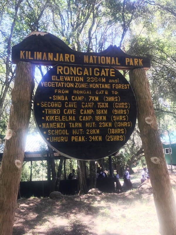
Day 1: Rongai Gate – First Cave’s Camp
- Altitudes (ASL): 1950m – 2600m,
- Distance covered: 8km,
- Trekking time: 4 hours,
- Habitat: Montane Forest
We will register at Marangu Park Gate and then transfer (approximately 2 ½ hours) to the Rongai trailhead. We will meet our porters before you begin your trek from the Nale Moru village. The small winding path crosses the fields of maize and Irish potatoes before climbing gently through a pine forest. The first night’s camp is at First Cave, at about 2,600m altitude.
Day 2: First Cave Camp – Kikelewa Cave Camp
- Elevation (m): 2600m to 3600m,
- Distance: 9km,
- Time: 6 – 7 hours,
- Habitat: Moorland
The trail continues up towards Kibo, passing Second Cave (3450m) en-route, and reaching Kikelewa Cave at 3600 meters. From here the views start to open up and you will see for yourself how huge a mountain Kilimanjaro really is. We overnight at Third Cave Camp (Kikelewa Caves).
Day 3: Kikelewa Cave Camp – Mawenzi Tarn Hut Camp
- Elevation (m): 3600m to 4330m,
- Distance covered: 6km,
- Trekking time: 4 hours,
- Habitat: Moorland
A short but steep climb up grassy slopes is rewarded by superb all-round views and a tangible sense of wilderness. We leave the vegetation behind shortly before reaching the next camp at Mawenzi Tarn (4330 m), spectacularly situated in a cirque directly beneath the towering spires of Mawenzi. The afternoon will be free to rest or explore the surrounding area as an aid to acclimatization.
Day 4: Mawenzi Tarn Hut Camp
- Elevation (m): 4330m,
- Habitat: Moorland
We will spend an extra day at Mawenzi Tarn to acclimatize. We will be able to trek and explore around Mawenzi Tarn and also rest ready to continue our trek up Kilimanjaro tomorrow.
Day 5: Mawenzi Tarn Hut Camp – Kibo Hut Campsite
- Altitudes (ASL): 4330m – 4703m,
- Distance covered: 4 km,
- Trekking time: 3 – 4 hours,
- Habitat: Alpine desert
We cross the lunar desert of the ‘Saddle’ between Mawenzi and Kibo to reach the Kibo campsite (4750m) at the bottom of the Kibo crater wall. The remainder of the day is spent resting in preparation for the final ascent tomorrow!
Day 6: Kibo Hut – Summit
- Altitudes (ASL): 4700m – 5895m,
- Distance covered: 21 km,
- Trekking time: 6 – 7 hours ascent, 3 hours descent to Kibo Hut, another 3 hours descent to Horombo Hut,
- Habitat: Stone screed and ice-capped summit and Moorland,
- Altitude gained (Kibo Hut – Summit): 1195m,
- Change in Altitude: Summit – Horombo Hut: (-2175m)
You will wake up around 11:30 pm, and after having some tea, popcorn, and biscuits you shuffle off into the night, and this is where the going really gets tough. The first section of the trail consists of a rocky path to the Hans Meyer point (5150m), also a good resting spot. The path then zigzags up to Gillman’s Point (5,685m), which is located on the crater rim. This section is very steep with a lot of stone screed, requiring a great physical and mental effort.
From Gillman’s Point, you will go westerly all the way up to Uhuru Peak (5895m), the highest point in Africa. Weather conditions on the summit will determine how long you will be able to spend, taking photographs before the 3 hours descent back to Kibo hut. After a short rest, you gather all the gear you left behind for the ascent and head down to Horombo hut (3 hours) for your overnight. Later in the evening, you enjoy your last dinner on the mountain and a well-earned sleep, filled with memories and stirring emotions.
Day 7: Horombo Hut – Marangu Gate
- Altitudes (ASL): 3720m – 1920m,
- Distance covered: 18 km,
- Trekking time: 6 hours,
- Change in Altitude: (-1800m)
After early breakfast, you will continue your descent (6 hours), passing the Mandara hut, down to the Marangu gate. On arrival there, you will sign for checking out and receiving your summit certificates. The successful climbers who reached Gillman’s Point (5685m) and Stella Point (5759m) are issued with silver certificates and those who reached Uhuru Peak (5895m), receive gold certificates. Our vehicle will meet at Marangu Gate and transfer you back to Arusha or Moshi for a hot shower, dinner, and overnight at the hotel/lodge
Included Services in 7 Days Rongai Route Hiking
- Transfers from/to Kilimanjaro airport (JRO)
- Transfers to/from Kilimanjaro entrance gate
- All national park gate fees
- Certified, experienced, English-speaking guides
- Porters and Cook salaries
- Rescue fees (required by national park)
- All meals on the mountain
- Mountain tents
- Double layered Sleeping Mats
- Filtered water throughout the trek
- Cooking equipment and eating utensils
- All government tax
Excluded Services to 7 Days Rongai Route
- International flights
- Travel insurance
- Visa fee
- Tips to mountain crew
- Laundry Services
- All items of a personal nature
- Portable flush toilet with a toilet tent is extra
The Trekking Gear for 7 Days Rongai Route Hiking
For the Head
Wool Hat, Balaclava, Sunglasses, glacier glasses better, Sunscreen (SPF 25+), Lip Balm (SPF 25+), Sun Hat, Bandana
Clothes (No Cotton)
Synthetic base layer (2) , Wool or synthetic layer (2), Wool or fleece sweater, Wind/Water-proof jacket, Convertible hiking pants, Underwear, Water-Proof Pants, Synthetic or wool pants for layering, Gloves or mittens, Glove Liner, Lycra tights.
For the Feet
Thin sock liners (2), Wool hiking socks (6), Good- broken-in hiking boots, Gaiters (knee lengthy is better), Tennis shoes or sandals (for camp)
For Sleeping
Zero degree sleeping bag, sleeping bag liner (optional), Inflatable pillow (optional)
For Hiking
Day pack (no larger than 2,200cu), Water bladder 100oz/3ltr, Rain cover for pack, Headlamp, Extra batteries, Large duffel bag for gear (porters carry), Energy bars/gels, Plastic bags
Personal Items
Toiletries, Small first aid kit, Small towel, Diamox for altitude sickness, Cash for tipping, Wet wipes, Bug Spray
Other Items
Sunglasses, Sunscreen (SPF 25+), Lip Balm (SPF 25+), Sun Hat, Bandana, Camera, Bug spray, Malaria pills, Flashlight/torch, Batteries, Cash for tips, etc.


