
Both the Lemosho and Shira routes approach Kilimanjaro from the west and cross the Shira Plateau. Lemosho is a relatively new route and is an improvement on the original Shira route as it starts much lower than Shira thus improving acclimatisation.
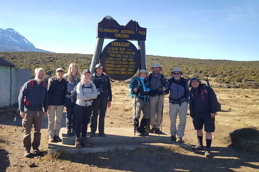
On the Shira route you will take a vehicle directly up to the Shira Gate to commence your trek up to Shira Camp where you will spend your first night at 3600m. The high altitude start on the Shira route is not recommended for good acclimatisation as climbers may experience symptoms of altitude on their first day. After day 1 the Lemosho and Shira routes merge.
The descent is along the Mweka Route, a descent-only route. The minimum time taken for the Lemosho route is 7 days, but again an extra day to acclimatise is recommended to improve the chances of summiting.
The Lemosho route is one of our highly recommended routes, not only for its beautiful scenery but also its’ high summit success due to the longer and steadier walk in improving acclimatisation. The first two days of the route have low traffic and are quite unspoilt, however, thereafter it joins with the Machame route to the summit.
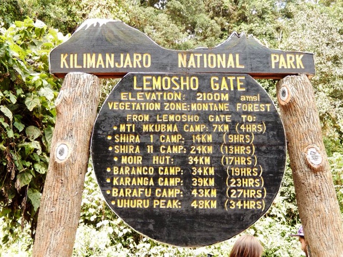
The Lemosho route starts from Londorossi Gate and the first two days are spent trekking through rainforest, where you may see wild game. It then traverses up to Shira Ridge, the third summit of Mt. Kilimanjaro. From here you will ascend and cross the expansive Shira Plateau with fantastic views of Shira Cathedral.
Day 1: Londorossi Gate / Mti Mkubwa Camp
- Elevation (m): 2360m / 2650m,
- Distance covered: 6 km,
- Trekking time: 3 – 4 hours,
- Habitat: Montane forest
Drive from the hotel/lodge to Londorossi Park Gate for orientation and registration. Meanwhile, our team of porters will prepare and pack the supplies and luggage before we drive to the starting point at Lemosho River glade for beginning our ascent along the forest trail to Mti Mkubwa (big tree) camp at 2650m. We will stay here overnight.
Day 2: Mti Mkubwa Camp / Shira 1 Camp
- Altitudes (ASL): 2650m / 3500m,
- Distance covered: 8 km,
- Trekking time: 6 – 7 hours,
- Habitat: Moorland
Leaving the forest behind, today’s trek with a height gain of over 600m through the moorland zone of giant heather will take us to a lunch stop at Shira beautiful valley just outside the Shira Crater at around 3050m. After lunch, the trail climbs steadily with wide views to reach the rim of the Shira Plateau and cross into the Shira Caldera a high altitude desert plateau rarely visited by man. Shira is the third of Kilimanjaro’s volcanic cones. It is filled with lava flow from Kibo, and its rim eroded and blasted away by weather and volcanic action. In an easterly direction, we will see the Western Breach with its stunning glaciers as on this day expect the first close views of Kibo, the dramatic summit cone of Kilimanjaro. There is a tangible sense of wilderness, especially if afternoon mists come in! We camp in the centre of the plateau for overnight. The night here is colder than the previous night and the temperature could possibly go below freezing.
Day 3: Shira 1 to Moir Hut
- Elevation (m): 3500m to 4200m,
- Distance: 14 km,
- Time: 5-7 hours,
- Habitat: Moorland
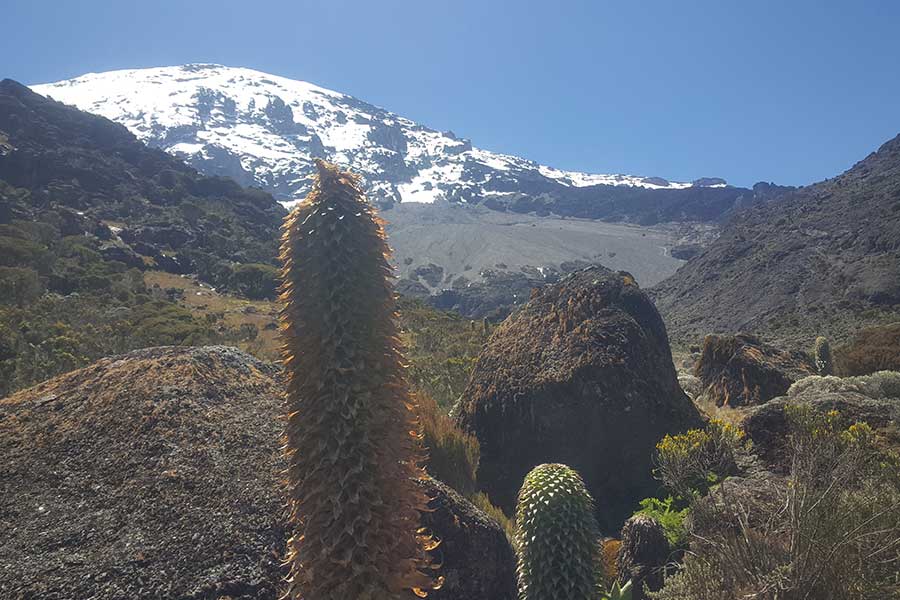
We leave the forest behind now, the trail gets steeper as it enters the moorland zone. A gentle grade walk takes you across the high altitude Shira Caldera to Shira Cave with fabulous views of Arrow glacier. We will camp here for the night at 4200m.
Day 4: Moir Hut via Lava Tower to Barranco Camp
- Elevation (m): 4200m to 4600m to 3950m,
- Distance: 12 km, Time: 6-7 hours,
- Habitat: Semi desert
Our route continues on a rocky and rugged eastward path as we ascend to the base of the Lava Tower at 4600m for lunch and acclimatisation. This will be our toughest day so far and you may, for the first time, feel the altitude. After lunch we will descend again by almost 650m to the Barranco camp. The high altitude of 4600m at Lava Tower and then descending to sleep will aid acclimatisation. Our descent to Barranco camp from Lava Tower takes about 2 hours and offers great opportunities to take some beautiful photographs of the Western Breach and Breach Wall. The camp is situated in a valley below the Breach and the Great Barranco Wall, which should provide you with a memorable sunset while you wait for your dinner.
Day 5: Barranco Camp / Barafu Hut Camp
- Altitudes (ASL): 3950m / 4600m,
- Distance covered: 9 km,
- Trekking time: 6-7 hours,
- Habitat: Alpine Desert
After breakfast, a short and fun scramble to the top of the Great Barranco Wall! We then traverse over scree ridges to the Karanga Valley (3930m) beneath the icefalls of the Heim, Kersten and Decken Glaciers. After climbing out of the Karanga Valley our trail ascends to Barafu Camp (4600m) where we will spend the night.
Day 6: Barafu Hut Camp / Summit / Millennium Hut Camp
- Altitudes (ASL): 4600m / 5895m (and down to 3797m),
- Distance covered: 7km ascent / 18km descent,
- Trekking time: 6 – 8 hours ascent / 6 – 7 hours descent,
- Habitat: Stone scree / ice-capped summit /Alpine desert,
- Altitudes Gained (Barafu Hut – Summit): 1295m, Altitude Gained; Summit – Mweka Hut: (-2098m)
Waking up at 11:30 pm with some quick tea and biscuits, we will start our ascent by torchlight at about 00:01 a.m with a slow but steady pace through heavy scree towards Stella Point (5732m) on the crater rim. This is the most mentally and physically challenging part of the trek. We will stop here for a short rest and will be rewarded with the most magnificent sunrise you are ever likely to see (if weather permitting). Those who are still feeling strong, can make the 1 ½ – 2 hour round trip from here along the crater rim passing close to the spectacular Rebmann glacier and ice cliffs that still occupy most of the summit area to Uhuru Peak (5,895 m), the highest point on Mount Kilimanjaro and African continent. From here, after the summit exploration and the photo celebration, the descent to Barafu is surprisingly fast, and after some refreshment, we continue to descend to reach Millennium Hut Camp (3797m), our final camp. Later in the evening, we will enjoy our last dinner on the mountain and a well-earned sleep.
Day 7: Millennium Hut Camp / Mweka Gate
- Altitudes (ASL): 3797m / 1800m,
- Distance covered: 12 km,
- Trekking time: 5- 6 hours,
- Habitat: Montane Forest,
- Altitude Gained: (-1997m)
Early morning after breakfast, you will proceed with descent down across the Alpine moorland to passing Mweka Hut on the way to Mweka Gate; a descent of about 6 hours. At lower elevations, it can be wet and muddy. Gaiters and trekking poles will help. Shorts and t-shirts will be suitable (keep rain gear and warmer clothing handy). Once at the Mweka Gate, you will sign out and followed by summit certificates representation. Here, you will be handed a Silver Certificate for having reached Stella Point (5732m), or a Gold Certificate for Uhuru Peak (5895m). After a short session of jubilation and farewell with your crew (guide/s, cook/s, and porters); and tipping of course, and having lunch you will take a waiting car and be transferred back to Arusha City where you will check in at your hotel/lodge for a welcome shower, dinner and overnight. [2 hour drive]
Included:
- Transfers from/to Kilimanjaro airport (JRO)
- Transfers to/from Kilimanjaro entrance gate
- All national park gate fees
- Certified, experienced, English-speaking guides
- Porters and Cook salaries
- Rescue fees (required by national park)
- All meals on the mountain
- Mountain tents
- Double layered Sleeping Mats
- Filtered water throughout the trek
- Cooking equipment and eating utensils
- All government tax
Excluded:
- International flights
- Travel insurance
- Visa fee
- Tips to mountain crew
- Laundry Services
- All items of a personal nature
- Portable flush toilet with a toilet tent is extra
For the Head
Wool Hat, Balaclava, Sunglasses, glacier glasses better, Sunscreen (SPF 25+), Lip Balm (SPF 25+), Sun Hat, Bandana
Clothes (No Cotton)
Synthetic base layer (2) , Wool or synthetic layer (2), Wool or fleece sweater, Wind/Water-proof jacket, Convertible hiking pants, Underwear, Water-Proof Pants, Synthetic or wool pants for layering, Gloves or mittens, Glove Liner, Lycra tights.
For the Feet
Thin sock liners (2), Wool hiking socks (6), Good- broken-in hiking boots, Gaiters (knee lengthy is better), Tennis shoes or sandals (for camp)
For Sleeping
Zero degree sleeping bag, sleeping bag liner (optional), Inflatable pillow (optional)
For Hiking
Day pack (no larger than 2,200cu), Water bladder 100oz/3ltr, Rain cover for pack, Headlamp, Extra batteries, Large duffel bag for gear (porters carry), Energy bars/gels, Plastic bags
Personal Items
Toiletries, Small first aid kit, Small towel, Diamox for altitude sickness, Cash for tipping, Wet wipes, Bug Spray
Other Items
Sunglasses, Sunscreen (SPF 25+), Lip Balm (SPF 25+), Sun Hat, Bandana, Camera, Bug spray, Malaria pills, Flashlight/torch, Batteries, Cash for tips, etc.


